
Mapa topográfico Le Moulin de Coisel
Mapa interactivo
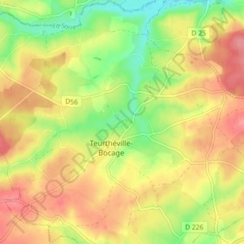
Haga clic en el mapa para ver la altitud.
Acerca de este mapa
Nombre: Mapa topográfico Le Moulin de Coisel, altitud, relieve.
Altitud media: 73 m
Altitud mínima: 29 m
Altitud máxima: 110 m
Otros mapas topográficos
Haga clic en un mapa para ver su topografía, su altitud y su relieve.
Hameau Gosselin
France > Normandie > Manche > Teurthéville-Bocage
Hameau Gosselin, Teurthéville-Bocage, Cherbourg, Manche, Normandie, France métropolitaine, 50630, France
Altitud media: 76 m
Sainte-Croix
France > Normandie > Manche > Teurthéville-Bocage
Sainte-Croix, Teurthéville-Bocage, Cherbourg, Manche, Normandie, France métropolitaine, 50630, France
Altitud media: 83 m
Hameau Cadel
France > Normandie > Manche > Teurthéville-Bocage
Hameau Cadel, Teurthéville-Bocage, Cherbourg, Manche, Normandie, France métropolitaine, 50630, France
Altitud media: 74 m