
Haz una donación
Mapa topográfico Kauai
Haga clic en el mapa para ver la altitud.
Haz una donación
Kauai
Kauaʻi's climate is tropical, with generally humid and stable conditions year-round, although weather phenomena and infrequent storms have caused instances of extreme weather. At the lower elevations, the annual precipitation varies from an average of about 50 in (130 cm) on the windward (northeastern) shore to less than 20 in (51 cm) on the (southwestern) leeward side of the island. The average temperature in Lihu'e, the county seat, ranges from 78 °F (26 °C) in February to 85 °F (29 °C) in August and September. Kauaʻi's mountainous regions offer cooler temperatures and a pleasant contrast to the warm coastal areas. At the Kōkeʻe state park, 3,200–4,200 ft (980–1,280 m) ASL, day temperatures vary from an average of 45 °F (7 °C) in January to 68 °F (20 °C) in July. In the winter, temperatures have been known to drop down to the 30s and 40s at Kōkeʻe state park, which holds an unofficial record low of 29 °F (−2 °C) recorded in February 1986 at Kanaloahuluhulu Meadow.
Haz una donación
Acerca de este mapa
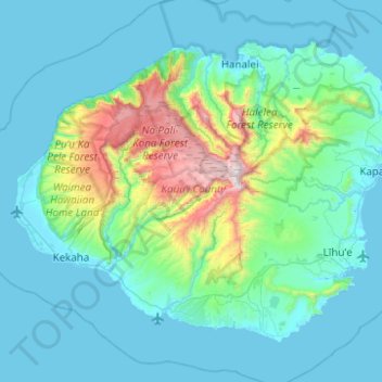
Nombre: Mapa topográfico Kauai, altitud, relieve.
Lugar: Kauai, Kauaʻi County, Hawaii, United States (21.86822 -159.78796 22.23271 -159.29232)
Altitud media: 216 m
Altitud mínima: 0 m
Altitud máxima: 1.568 m
Haz una donación
Otros mapas topográficos
Haga clic en un mapa para ver su topografía, su altitud y su relieve.
Haz una donación
Haz una donación
Haz una donación
Haz una donación