
Mapa topográfico Colfax
Mapa interactivo
Haga clic en el mapa para ver la altitud.
Acerca de este mapa
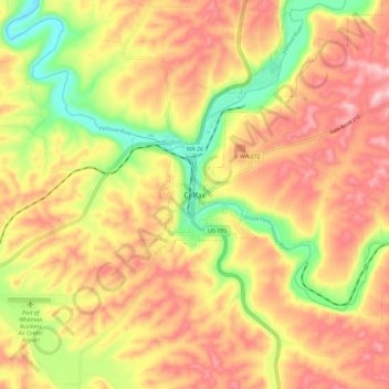
Nombre: Mapa topográfico Colfax, altitud, relieve.
Lugar: Colfax, Whitman County, Washington, 99111, United States (46.84017 -117.40435 46.92017 -117.32435)
Altitud media: 689 m
Altitud mínima: 573 m
Altitud máxima: 779 m
Colfax is located in southeastern Washington at 46°53′3″N 117°21′49″W / 46.88417°N 117.36361°W / 46.88417; -117.36361 (46.884033, -117.363668), at an elevation of 1,962 feet (598 m). The nearest cities are Spokane, Pullman, Moscow, and Lewiston/Clarkston. The area is geologically interesting, lying in the midst of the fertile Palouse country in the middle of the Columbia River Plateau, with the Rocky Mountains to the east, the Channeled Scablands to the west, and the Snake River to the south.