
Mapa topográfico Corrèze
Mapa interactivo
Haga clic en el mapa para ver la altitud.
Acerca de este mapa
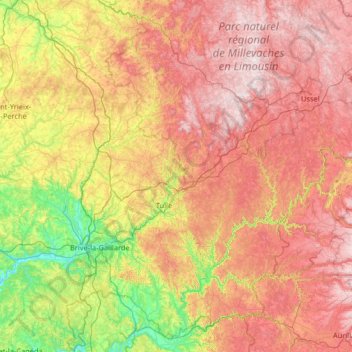
Nombre: Mapa topográfico Corrèze, altitud, relieve.
Lugar: Corrèze, New Aquitaine, Metropolitan France, France (44.92049 1.22696 45.76528 2.52866)
Altitud media: 481 m
Altitud mínima: 77 m
Altitud máxima: 975 m
The department transitions between the Aquitaine and the Massif Central, the Corrèze department sees its elevation gradually rise from the basin of Brive to the Plateau de Millevaches, watershed of the Atlantic facade. This relief explains the wide variety of climates of Corrèze.
Otros mapas topográficos
Haga clic en un mapa para ver su topografía, su altitud y su relieve.