
Haz una donación
Mapa topográfico Annapolis
Haga clic en el mapa para ver la altitud.
Haz una donación
Annapolis
Annapolis lies within the humid subtropical climate zone (Köppen Cfa), with hot, humid summers, cool winters, and generous precipitation year-round. Low elevation and proximity to the Chesapeake Bay give the area more moderate spring and summertime temperatures and slightly less extreme winter lows than locations further inland, such as Washington, D.C.
Haz una donación
Acerca de este mapa
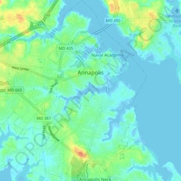
Nombre: Mapa topográfico Annapolis, altitud, relieve.
Lugar: Annapolis, Anne Arundel County, Maryland, United States (38.94250 -76.53958 39.00255 -76.46868)
Altitud media: 8 m
Altitud mínima: -5 m
Altitud máxima: 34 m
Haz una donación
Otros mapas topográficos
Haga clic en un mapa para ver su topografía, su altitud y su relieve.
Haz una donación
Quiet Waters Park
United States > Maryland > Anne Arundel County > Annapolis > Georgetown East
Altitud media: 7 m
Haz una donación
Haz una donación
Haz una donación
Haz una donación
Haz una donación
Haz una donación
Pasadena
United States > Maryland > Anne Arundel County
Pasadena is located at 39°6′46″N 76°33′7″W / 39.11278°N 76.55194°W / 39.11278; -76.55194 (39.112809, −76.551871) in northern Anne Arundel County. It is bordered to the north by the city of Baltimore, to the east by the tidal Patapsco River and by Riviera Beach, to the southeast by Lake…
Altitud media: 16 m
Haz una donación
Haz una donación
Haz una donación
Haz una donación
Haz una donación
Haz una donación
Haz una donación
Haz una donación
Haz una donación
Orchard Beach
United States > Maryland > Anne Arundel County > Riviera Beach > Orchard Beach
Altitud media: 6 m
Haz una donación