
Haz una donación
Mapa topográfico Privas
Haga clic en el mapa para ver la altitud.
Haz una donación
Privas
During the siege of 1629, the town of Privas was well defended by walls and ditches. Privas also has gorges to its south, east and north that provide a natural defence. Given this topography, the Huguenots in the town did not believe that a strong attack from the east was possible. Nevertheless, on 22 May, the Swiss mercenaries of the attacking Royalist Catholic army of Cardinal Richelieu managed to haul by hand six huge pieces of artillery, each weighing about four tons, from Tauléac across the Ouvèze river and up the zig-zag path onto the plateau of Le Vanel, to the east of the town walls. From this decisive vantage point they bombarded the town until its surviving defenders were forced to evacuate and take their last stand on Mont Toulon on its west. During the siege, five hundred Royalist attackers and one thousand Protestant defenders were killed. Surviving defenders were executed, imprisoned, or deported to be galley slaves. By fire or cannon, the majority of the buildings in the town were destroyed. Privas was a ghost town for many years after. It is estimated that as a result of the defeat of the Huguenots in the region, one-fifth of the Protestant population of the Ardèche emigrated. After the defeat of the Camisard revolt (1702–1715) a further 50,000 Archèche Protestants left France. Many fled to England or Switzerland.
Haz una donación
Acerca de este mapa
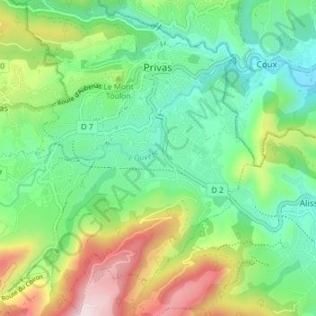
Nombre: Mapa topográfico Privas, altitud, relieve.
Altitud media: 367 m
Altitud mínima: 174 m
Altitud máxima: 763 m
Haz una donación
Otros mapas topográficos
Haga clic en un mapa para ver su topografía, su altitud y su relieve.
Haz una donación
Haz una donación
Haz una donación
Haz una donación
Saint-Pierre-la-Roche
France > Auvergne-Rhône-Alpes > Ardèche > Saint-Pierre-la-Roche > Saint-Pierre-la-Roche
Altitud media: 461 m
Haz una donación