
Haz una donación
Mapa topográfico Canyon
Haga clic en el mapa para ver la altitud.
Haz una donación
Canyon
Canyon, formerly known as Sequoya, is an unincorporated community located near the border of Contra Costa and Alameda counties, in the U.S. state of California. It is situated between Oakland and Moraga in the San Francisco Bay Area. The community is named for its location in the upper canyon of San Leandro Creek along the eastern slope of the Berkeley Hills. Canyon lies at an elevation of 1138 feet (347 m).
Haz una donación
Acerca de este mapa
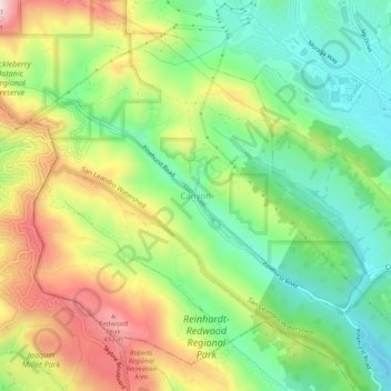
Nombre: Mapa topográfico Canyon, altitud, relieve.
Altitud media: 292 m
Altitud mínima: 137 m
Altitud máxima: 517 m
Haz una donación
Otros mapas topográficos
Haga clic en un mapa para ver su topografía, su altitud y su relieve.
Bayview-Montalvin
United States > California > Contra Costa County > Pinole > Gateley
Altitud media: 17 m
Camino Tassajara
United States > California > Contra Costa County > Camino Tassajara
Camino Tassajara (Spanish for "Path of Carne Seca") is a census-designated place in Contra Costa County, California. Camino Tassajara sits at an elevation of 814 feet (248 m). The 2010 United States census reported Camino Tassajara's population was 2,197.
Altitud media: 233 m
Haz una donación
Morgan Territory Regional Preserve
United States > California > Contra Costa County
Altitud media: 449 m
Haz una donación
Mount Diablo State Park
United States > California > Contra Costa County > Clayton
Mount Diablo is a mountain of the Diablo Range, in Contra Costa County of the eastern San Francisco Bay Area in Northern California. It is south of Clayton and northeast of Danville. It is an isolated upthrust peak of 3,849 feet (1,173 meters), visible from most of the San Francisco Bay Area. Mount Diablo…
Altitud media: 334 m
John Muir National Historic Site
United States > California > Contra Costa County > Martinez > Muir
Altitud media: 94 m
Haz una donación
Eugene O'Neill National Historic Site
United States > California > Contra Costa County > Alamo
Altitud media: 237 m