
Gracias por apoyar a este sitio ❤️
Haz una donación
Haz una donación
Mapa topográfico Jhargram
Haga clic en el mapa para ver la altitud.
Gracias por apoyar a este sitio ❤️
Haz una donación
Haz una donación
Jhargram
Jhargram is located at 22°27′N 86°59′E / 22.45°N 86.98°E / 22.45; 86.98. It has an average elevation of 81 metres (265 feet). The weather, like much of Bengal, is extremely humid and tropical. Temperatures can reach as high as 46 °C in the hot and dry months of May and June but can plummet to 4 °C in the chilly nights of December and January.
Gracias por apoyar a este sitio ❤️
Haz una donación
Haz una donación
Acerca de este mapa
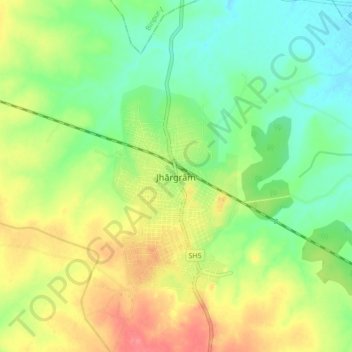
Nombre: Mapa topográfico Jhargram, altitud, relieve.
Lugar: Jhargram, West Bengal, 721507, India (22.41385 86.95495 22.49385 87.03495)
Altitud media: 79 m
Altitud mínima: 51 m
Altitud máxima: 116 m
Gracias por apoyar a este sitio ❤️
Haz una donación
Haz una donación