
Haz una donación
Mapa topográfico Altamont Pass
Haga clic en el mapa para ver la altitud.
Haz una donación
Altamont Pass
Altamont Pass, formerly Livermore Pass, is a low mountain pass in the Diablo Range of Northern California between Livermore in the Livermore Valley and Tracy in the San Joaquin Valley. The name is actually applied to two distinct but nearby crossings of the range. The lower of the two, at an elevation of 741 ft (226 m), carries two railroad rights-of-way (ROWs) and Altamont Pass Road, part of the old Lincoln Highway and the original alignment of US 50 before it was bypassed c. 1937. The bypass route travels over the higher summit, at 1,009 ft (308 m), and now carries Interstate 580, a major regional highway heavily congested by Central Valley suburbanization.
Haz una donación
Acerca de este mapa
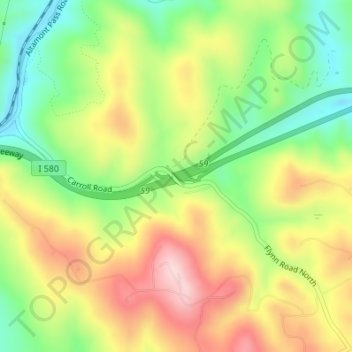
Nombre: Mapa topográfico Altamont Pass, altitud, relieve.
Lugar: Altamont Pass, Alameda County, California, United States (37.71938 -121.66044 37.71948 -121.66034)
Altitud media: 339 m
Altitud mínima: 217 m
Altitud máxima: 476 m
Haz una donación
Otros mapas topográficos
Haga clic en un mapa para ver su topografía, su altitud y su relieve.
Reinhardt-Redwood Regional Park
United States > California > Alameda County > Oakland
Altitud media: 292 m
Haz una donación
Quarry Lakes Regional Park
United States > California > Alameda County > Fremont > Eberly
Altitud media: 17 m
Haz una donación
Dougherty Hills Open Space
United States > California > Alameda County > Dublin > Komandorski Village
Altitud media: 120 m
Lake Del Valle
United States > California > Alameda County
The dam is 230 feet (70 m) high and 880 feet (270 m) long. Its crest elevation is 773 feet (236 m). The dam contains 4,150,000 cubic yards (3,170,000 m3) of earth fill.
Altitud media: 339 m
Haz una donación