
Haz una donación
Mapa topográfico Yellow Sulphur
Haga clic en el mapa para ver la altitud.
Haz una donación
Acerca de este mapa
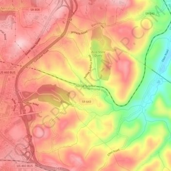
Nombre: Mapa topográfico Yellow Sulphur, altitud, relieve.
Altitud media: 594 m
Altitud mínima: 453 m
Altitud máxima: 669 m
Haz una donación
Otros mapas topográficos
Haga clic en un mapa para ver su topografía, su altitud y su relieve.
Blacksburg
United States > Virginia > Montgomery County
Blacksburg exhibits a varied topography characterized by its rolling hills and elevation changes. The town is situated at an average elevation of approximately 2,040 feet (621 meters) above sea level, with elevations ranging from about 1,440 feet (440 meters) to peaks reaching approximately 2,800 feet (860…
Altitud media: 621 m
Haz una donación
Blacksburg
United States > Virginia > Montgomery County
In the mid-1600s, English colonists were still uncertain of what lay beyond the Allegheny Mountains, whose topography and possession by native inhabitants, Tutelo-speaking tribes, were a barrier to expanded settlement by the Colony of Virginia. Abraham Wood, who commanded Fort Henry on the frontier (now the…
Altitud media: 621 m