
Gracias por apoyar a este sitio ❤️
Haz una donación
Haz una donación
Mapa topográfico West Roxbury
Haga clic en el mapa para ver la altitud.
Gracias por apoyar a este sitio ❤️
Haz una donación
Haz una donación
Acerca de este mapa
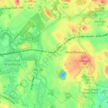
Nombre: Mapa topográfico West Roxbury, altitud, relieve.
Altitud media: 42 m
Altitud mínima: -24 m
Altitud máxima: 100 m
Gracias por apoyar a este sitio ❤️
Haz una donación
Haz una donación
Otros mapas topográficos
Haga clic en un mapa para ver su topografía, su altitud y su relieve.
Boston
United States > Massachusetts > Suffolk County > Boston
Boston has an area of 89.63 sq mi (232.1 km2)—48.4 sq mi (125.4 km2) (54%) of land and41.2 sq mi (106.7 km2) (46%) of water. The city's official elevation, as measured at Logan International Airport, is 19 ft (5.8 m) above sea level. The highest point in Boston is Bellevue Hill at 330 ft (100 m) above sea…
Altitud media: 26 m
Gracias por apoyar a este sitio ❤️
Haz una donación
Haz una donación