
Haz una donación
Mapa topográfico Culver
Haga clic en el mapa para ver la altitud.
Haz una donación
Acerca de este mapa
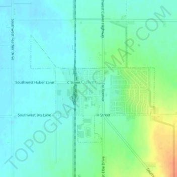
Nombre: Mapa topográfico Culver, altitud, relieve.
Lugar: Culver, Jefferson County, Oregon, United States (44.51631 -121.22550 44.53268 -121.19909)
Altitud media: 807 m
Altitud mínima: 795 m
Altitud máxima: 838 m
Haz una donación
Otros mapas topográficos
Haga clic en un mapa para ver su topografía, su altitud y su relieve.
Mount Jefferson
United States > Oregon > Jefferson County
The second tallest mountain in the U.S. state of Oregon after Mount Hood, Mount Jefferson lies within Jefferson, Linn, and Marion counties, in the central part of the state. Reaching an elevation of 10,497 feet (3,199 m), the volcano has a proximal relief of 4,890 feet (1,490 m). It is not usually visible from…
Altitud media: 2.537 m
Black Butte
United States > Oregon > Jefferson County
According to the U.S. National Geodetic Survey and scientists from the United States Geological Survey, Black Butte has an elevation of 6,436 feet (1,962 m); the Geographic Names Information System database lists its elevation as 6,430 feet (1,960 m), while Oregon Geographic Names lists its elevation at 6,415…
Altitud media: 1.514 m
Mount Jefferson
United States > Oregon > Jefferson County
The second tallest mountain in the U.S. state of Oregon after Mount Hood, Mount Jefferson lies within Jefferson, Linn, and Marion counties, in the central part of the state. Reaching an elevation of 10,497 feet (3,199 m), the volcano has a proximal relief of 4,890 feet (1,490 m). It is not usually visible from…
Altitud media: 2.537 m
Haz una donación