
Haz una donación
Mapa topográfico Gonzaga
Haga clic en el mapa para ver la altitud.
Haz una donación
Gonzaga
It has a total land area of 56,743 hectares (140,220 acres), the majority of which remains undeveloped. It has large stretches of virgin forests, especially throughout the mountainous areas of the Sierra Madre mountain range. The highest elevation in the municipality is 1,130 metres (3,710 ft) above sea level, located at Mount Cagua in Barangay Magrafil.
Haz una donación
Acerca de este mapa
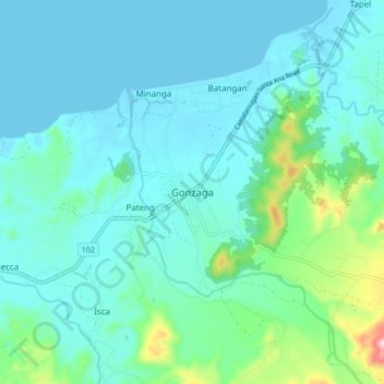
Nombre: Mapa topográfico Gonzaga, altitud, relieve.
Lugar: Gonzaga, Cagayan, Cagayan Valley, 3513, Philippines (18.22120 121.95665 18.30120 122.03665)
Altitud media: 38 m
Altitud mínima: -1 m
Altitud máxima: 237 m
Haz una donación
Otros mapas topográficos
Haga clic en un mapa para ver su topografía, su altitud y su relieve.
Fuga Island
Fuga has an area of 70 square kilometres (27 sq mi) and a population of 2,015 people. The principal settlement is Naguilian (Musa) village on the southern coast. The highest peak is Mount Nanguringan in the northeast, with an elevation of 191 metres (627 ft).
Altitud media: 9 m
Haz una donación
Dalupiri Island
Philippines > Cagayan > Calayan
Dalupiri Island lies about 45 km (28 mi) north of Luzon and about 15 km (9.3 mi) north of Fuga Island. The island has an elongated elliptical shape orientated along a north–south axis, the island has a length of about 18 km (11 mi), with a width of about 7 km (4.3 mi) at its widest point. The topography of…
Altitud media: 25 m