
Mapa topográfico Groton
Mapa interactivo
Haga clic en el mapa para ver la altitud.
Acerca de este mapa
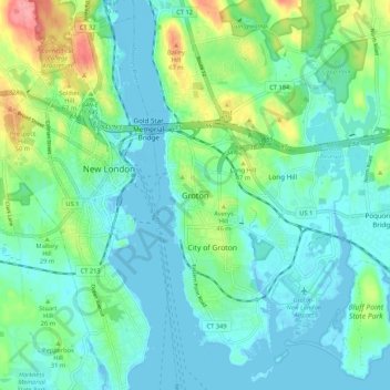
Nombre: Mapa topográfico Groton, altitud, relieve.
Lugar: Groton, New London County, Connecticut, 06340, United States (41.31016 -72.11620 41.39016 -72.03620)
Altitud media: 21 m
Altitud mínima: -3 m
Altitud máxima: 91 m
Otros mapas topográficos
Haga clic en un mapa para ver su topografía, su altitud y su relieve.
Groton Long Point
United States > Connecticut > New London County > Groton > Groton Long Point
Groton Long Point, Groton, New London County, Connecticut, United States
Altitud media: 2 m
Noank
United States > Connecticut > New London County > Groton > Noank
Noank, Groton, New London County, Connecticut, United States
Altitud media: 15 m
Poquonock Bridge
United States > Connecticut > New London County > Groton > Poquonock Bridge
Poquonock Bridge, Groton, New London County, Connecticut, United States
Altitud media: 20 m