
Haz una donación
Mapa topográfico Machilipatnam
Haga clic en el mapa para ver la altitud.
Haz una donación
Machilipatnam
Salabat Jung, the son of Nizam-ul-Mulk Asaf Jah I, who was indebted for his elevation to the throne to the French East India Company, granted them in return for their services the district of Kondavid or Guntur, and soon afterwards the remainder of the Circars. The Circars were captured by the British from the French in 1759 and were returned to the Nizam. However Masulipatnam captured by the British during the Siege of Masulipatam was retained by the East India Company.
Haz una donación
Acerca de este mapa
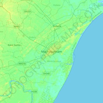
Nombre: Mapa topográfico Machilipatnam, altitud, relieve.
Lugar: Machilipatnam, Krishna district, Andhra Pradesh, 521001, India (16.02174 80.97482 16.34174 81.29482)
Altitud media: 4 m
Altitud mínima: -4 m
Altitud máxima: 13 m
Haz una donación
Otros mapas topográficos
Haga clic en un mapa para ver su topografía, su altitud y su relieve.