
Haz una donación
Mapa topográfico Platina
Haga clic en el mapa para ver la altitud.
Haz una donación
Acerca de este mapa
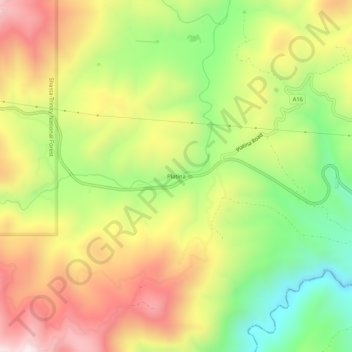
Nombre: Mapa topográfico Platina, altitud, relieve.
Lugar: Platina, Shasta County, California, 96076, United States (40.33959 -122.91474 40.37959 -122.87474)
Altitud media: 770 m
Altitud mínima: 420 m
Altitud máxima: 1.136 m
Haz una donación
Otros mapas topográficos
Haga clic en un mapa para ver su topografía, su altitud y su relieve.
Redding
United States > California > Shasta County
The elevation in Redding is 495 feet (151 meters) on average, whereas anywhere to the north, east, or west of downtown ranges between 550 feet (170 m) and 800 feet (240 m) feet. Southern portions range between 400 feet (120 m) and 500 feet (150 m).
Altitud media: 240 m
Redding
United States > California > Shasta County
The elevation in Redding is 495 feet (151 meters) on average, whereas anywhere to the north, east, or west of downtown ranges between 550 feet (170 m) and 800 feet (240 m) feet. Southern portions range between 400 feet (120 m) and 500 feet (150 m).
Altitud media: 241 m
Haz una donación
Haz una donación
Whiskeytown-Shasta-Trinity National Recreation Area - Shasta Unit
United States > California > Shasta County
Altitud media: 612 m
Lassen Volcanic National Park
United States > California > Shasta County
According to the Köppen climate classification system, Lassen Volcanic National Park has a Mediterranean-influenced warm-summer Humid continental climate (Dsb). According to the United States Department of Agriculture, the Plant Hardiness zone at Kohm Yah-mah-nee Visitor Center at 6,736 ft (2,053 m) elevation…
Altitud media: 1.972 m
Haz una donación
Lassen Volcanic National Park
United States > California > Shasta County
According to the Köppen climate classification system, Lassen Volcanic National Park has a Mediterranean-influenced warm-summer Humid continental climate (Dsb). According to the United States Department of Agriculture, the Plant Hardiness zone at Kohm Yah-mah-nee Visitor Center at 6,736 ft (2,053 m) elevation…
Altitud media: 1.972 m
Redding
United States > California > Shasta County
The elevation in Redding is 495 feet (151 meters) on average, whereas anywhere to the north, east, or west of downtown ranges between 550 and 800 feet (170 and 240 m). Southern portions range between 400 and 500 feet (120 and 150 m).
Altitud media: 241 m
Haz una donación
Haz una donación
Lassen Volcanic National Park
United States > California > Shasta County
According to the Köppen climate classification system, Lassen Volcanic National Park has a Mediterranean-influenced warm-summer Humid continental climate (Dsb). According to the United States Department of Agriculture, the Plant Hardiness zone at Kohm Yah-mah-nee Visitor Center at 6,736 ft (2,053 m) elevation…
Altitud media: 1.972 m
Palo Cedro
United States > California > Shasta County
Palo Cedro is located at 40°33′4″N 122°14′3″W / 40.55111°N 122.23417°W / 40.55111; -122.23417 (40.551091, −122.234255) at an elevation of 465 ft (143 m) above sea level.
Altitud media: 157 m
Haz una donación
Palo Cedro
United States > California > Shasta County
Palo Cedro is located at 40°33′4″N 122°14′3″W / 40.55111°N 122.23417°W / 40.55111; -122.23417 (40.551091, −122.234255) at an elevation of 465 ft (143 m) above sea level.
Altitud media: 157 m
Whiskeytown-Shasta-Trinity National Recreation Area - Shasta Unit
United States > California > Shasta County
Altitud media: 612 m