
Gracias por apoyar a este sitio ❤️
Haz una donación
Haz una donación
Mapa topográfico Thayne
Haga clic en el mapa para ver la altitud.
Gracias por apoyar a este sitio ❤️
Haz una donación
Haz una donación
Thayne
Thayne is located at 42°55′11″N 111°0′3″W / 42.91972°N 111.00083°W / 42.91972; -111.00083 (42.919754, –111.000714), at 5906 feet in elevation. It sits in the northern portion of Wyoming's grassy Star Valley, close to the Salt River. Thayne is surrounded by green grassland and ranches, with forested mountains at the valley's edge.
Gracias por apoyar a este sitio ❤️
Haz una donación
Haz una donación
Acerca de este mapa
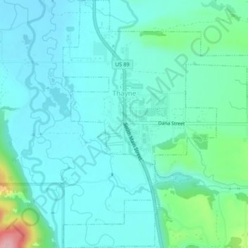
Nombre: Mapa topográfico Thayne, altitud, relieve.
Lugar: Thayne, Lincoln County, Wyoming, 83127, United States (42.90253 -111.01238 42.93177 -110.97281)
Altitud media: 1.814 m
Altitud mínima: 1.783 m
Altitud máxima: 1.961 m
Gracias por apoyar a este sitio ❤️
Haz una donación
Haz una donación
Otros mapas topográficos
Haga clic en un mapa para ver su topografía, su altitud y su relieve.