
Mapa topográfico Villalba
Mapa interactivo
Haga clic en el mapa para ver la altitud.
Acerca de este mapa
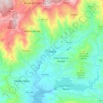
Nombre: Mapa topográfico Villalba, altitud, relieve.
Lugar: Villalba, Puerto Rico, 00766, United States (18.08835 -66.53250 18.16835 -66.45250)
Altitud media: 406 m
Altitud mínima: 97 m
Altitud máxima: 1.086 m
Villalba is located in the central region of Puerto Rico, on a valley in the Cordillera Central. The highest point in the municipality is Cerro El Bolo at 3,526 feet (1,075 m) of elevation.