
Haz una donación
Mapa topográfico Danby
Haga clic en el mapa para ver la altitud.
Haz una donación
Danby
Dorset Peak, part of the Taconic range, lies on the town's southern border and reaches an elevation of 3,804 feet (1,159 m). Danby quarry, located near the peak, opened in the early 20th century and is likely the world's largest underground marble quarry. It was reported in 2001 to have a total monthly output of about 1,200 tons of marble, half of which consists of Imperial Danby, a fine architectural marble with a variety of uses. Danby marble has been used in a number of notable buildings, including the United States Supreme Court building and the Jefferson Memorial.
Haz una donación
Acerca de este mapa
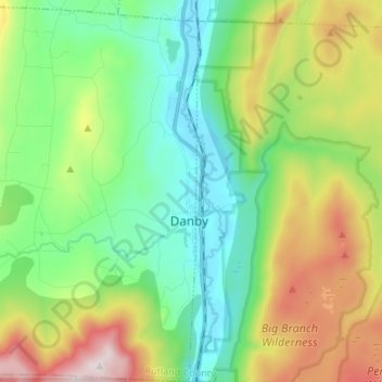
Nombre: Mapa topográfico Danby, altitud, relieve.
Lugar: Danby, Rutland County, Vermont, 05739, United States (43.30517 -73.12266 43.40301 -72.99342)
Altitud media: 499 m
Altitud mínima: 189 m
Altitud máxima: 1.141 m
Haz una donación
Otros mapas topográficos
Haga clic en un mapa para ver su topografía, su altitud y su relieve.
Danby
United States > Vermont > Rutland County
Dorset Peak, part of the Taconic range, lies on the town's southern border and reaches an elevation of 3,804 feet (1,159 m). Danby quarry, located near the peak, opened in the early 20th century and is likely the world's largest underground marble quarry. It was reported in 2001 to have a total monthly output…
Altitud media: 303 m
Haz una donación
Valley Park
United States > Vermont > Rutland County > Killington > Sherburne Center
Altitud media: 506 m
Haz una donación