
Mapa topográfico Indian Springs
Mapa interactivo
Haga clic en el mapa para ver la altitud.
Acerca de este mapa
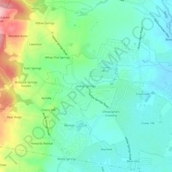
Nombre: Mapa topográfico Indian Springs, altitud, relieve.
Altitud media: 143 m
Altitud mínima: 94 m
Altitud máxima: 266 m
Terrain in the area is generally rugged with elevations between 600 and 1,900 feet (580 m) above sea level, the landscape being primarily wooded. The terrain here differs greatly from the neighboring Hagerstown Valley, where elevations average less than 650' and is characterized by fertile, gently rolling hills. While land for farming is not as readily available in the Springs area, orchards have been a source of local livelihood for centuries.
Otros mapas topográficos
Haga clic en un mapa para ver su topografía, su altitud y su relieve.
Rosedale
United States > Maryland > Frederick County > Frederick
Rosedale, Frederick, Frederick County, Maryland, 21709, United States
Altitud media: 100 m
Frederick
United States > Maryland > Frederick County > Frederick
Frederick, Frederick County, Maryland, 21701-4546, United States
Altitud media: 165 m
Villa Estates
United States > Maryland > Frederick County > Frederick > Villa Estates
Villa Estates, Frederick, Frederick County, Maryland, 21701-4546, United States
Altitud media: 103 m