
Mapa topográfico Taiyuan City
Mapa interactivo
Haga clic en el mapa para ver la altitud.
Acerca de este mapa
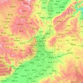
Nombre: Mapa topográfico Taiyuan City, altitud, relieve.
Lugar: Taiyuan City, Shanxi, China (37.44142 111.50892 38.42085 113.14779)
Altitud media: 1.195 m
Altitud mínima: 550 m
Altitud máxima: 2.376 m
Taiyuan experiences a cold semi-arid climate (Köppen climate classification BSk). Taiyuan has a temperate monsoon climate. Spring is dry, with occasional dust storms, followed by early summer heat waves. Summer tends to be warm to hot with most of the year's rainfall concentrated in July and August. Winter is long and cold, but dry and sunny. Because of the aridity, there tends to be considerable diurnal variation in temperature, except during the summer. The weather is much cooler than comparable-latitude cities, such as Shijiazhuang, due to the moderately high altitude. The monthly 24-hour average temperature range from −5.0 °C (23.0 °F) in January to 24.0 °C (75.2 °F) in July, while the annual mean is 10.42 °C (50.8 °F). With monthly percent possible sunshine ranging from 51 percent in July to 61 percent in May, there are 2,502 hours of sunshine annually.
Otros mapas topográficos
Haga clic en un mapa para ver su topografía, su altitud y su relieve.
Pingcheng District
China > Shanxi > Pingcheng District
Datong, Pingcheng District, Datong City, Shanxi, 037004, China
Altitud media: 1.149 m