
Haz una donación
Mapa topográfico Redding
Haga clic en el mapa para ver la altitud.
Haz una donación
Redding
Redding's topography is dominated by three ridges, running north to south, with intervening valleys featuring steep slopes and rocky ledges in some sections. The highest elevation is about 830 feet above sea level, on Sunset Hill in the northeast part of the town; and the low elevation is about 290 feet above sea level at the Saugatuck Reservoir along the southern border.
Haz una donación
Acerca de este mapa
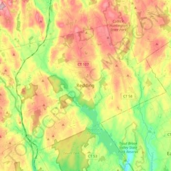
Nombre: Mapa topográfico Redding, altitud, relieve.
Altitud media: 160 m
Altitud mínima: 37 m
Altitud máxima: 292 m
Haz una donación
Otros mapas topográficos
Haga clic en un mapa para ver su topografía, su altitud y su relieve.
Old Greenwich
United States > Connecticut > Western Connecticut Planning Region > Greenwich
Altitud media: 12 m
Sandy Hook
United States > Connecticut > Western Connecticut Planning Region > Newtown
Altitud media: 113 m
Candlewood Lake Club
United States > Connecticut > Western Connecticut Planning Region > New Milford
Altitud media: 143 m
Cannondale
United States > Connecticut > Western Connecticut Planning Region > Wilton
Altitud media: 110 m
Haz una donación
Taylor Corners
United States > Connecticut > Western Connecticut Planning Region > New Fairfield
Altitud media: 226 m
Mianus
United States > Connecticut > Western Connecticut Planning Region > Greenwich
Altitud media: 23 m
Winnipauk
United States > Connecticut > Western Connecticut Planning Region > Norwalk
Altitud media: 51 m
West Norwalk
United States > Connecticut > Western Connecticut Planning Region > Norwalk
Altitud media: 50 m
Haz una donación
Godfrey Corner
United States > Connecticut > Western Connecticut Planning Region > Weston
Altitud media: 110 m
North Mianus
United States > Connecticut > Western Connecticut Planning Region > Greenwich
Altitud media: 32 m
Saugatuck
United States > Connecticut > Western Connecticut Planning Region > Westport
Altitud media: 15 m
Five Points
United States > Connecticut > Western Connecticut Planning Region > Redding Ridge
Altitud media: 185 m
Haz una donación
Daniels Mill
United States > Connecticut > Western Connecticut Planning Region > New Canaan
Altitud media: 100 m
Thomas Mountain
United States > Connecticut > Western Connecticut Planning Region > Danbury
Altitud media: 197 m
Germantown
United States > Connecticut > Western Connecticut Planning Region > Danbury
Altitud media: 121 m
King Street
United States > Connecticut > Western Connecticut Planning Region > Danbury
Altitud media: 237 m
Haz una donación
Pinneys Corners
United States > Connecticut > Western Connecticut Planning Region > New Canaan
Altitud media: 143 m
Riverside
United States > Connecticut > Western Connecticut Planning Region > Greenwich > Old Greenwich
Altitud media: 13 m
Beaver Brook
United States > Connecticut > Western Connecticut Planning Region > Danbury
Altitud media: 119 m
King Street
United States > Connecticut > Western Connecticut Planning Region > Danbury
Altitud media: 237 m
Haz una donación
North Stamford
United States > Connecticut > Western Connecticut Planning Region > Stamford
Altitud media: 89 m
Mianus
United States > Connecticut > Western Connecticut Planning Region > Greenwich
Altitud media: 23 m
Five Points
United States > Connecticut > Western Connecticut Planning Region > Redding Ridge
Altitud media: 185 m
Ponus
United States > Connecticut > Western Connecticut Planning Region > New Canaan
Altitud media: 77 m
Haz una donación
Great Plain
United States > Connecticut > Western Connecticut Planning Region > Danbury
Altitud media: 132 m
Byram
United States > Connecticut > Western Connecticut Planning Region > Greenwich
Altitud media: 19 m
Wataba Lake
United States > Connecticut > Western Connecticut Planning Region > Ridgefield
Altitud media: 205 m
Tokeneke
United States > Connecticut > Western Connecticut Planning Region > Darien
Altitud media: 14 m
Haz una donación
Roxbury
United States > Connecticut > Western Connecticut Planning Region > Stamford
Altitud media: 48 m
Deer Hill
United States > Connecticut > Western Connecticut Planning Region > Danbury
Altitud media: 135 m
Long Ridge
United States > Connecticut > Western Connecticut Planning Region > Stamford
Altitud media: 126 m
King Street
United States > Connecticut > Western Connecticut Planning Region > Danbury
Altitud media: 237 m
Haz una donación
Northfield
United States > Connecticut > Western Connecticut Planning Region > Stamford
Altitud media: 25 m
Town Open Space (Ashford Lane)
United States > Connecticut > Western Connecticut Planning Region > Newtown
Altitud media: 200 m
South End
United States > Connecticut > Western Connecticut Planning Region > Stamford
Altitud media: 11 m
Godfrey Corner
United States > Connecticut > Western Connecticut Planning Region > Weston
Altitud media: 110 m
Haz una donación
Bold Rock
United States > Connecticut > Western Connecticut Planning Region > Darien
Altitud media: 58 m
Mill River Park
United States > Connecticut > Western Connecticut Planning Region > Stamford
Altitud media: 18 m
Wildmans Landing
United States > Connecticut > Western Connecticut Planning Region > Danbury
Altitud media: 156 m
Chimney Point
United States > Connecticut > Western Connecticut Planning Region > New Milford
Altitud media: 142 m
Haz una donación
Palestine
United States > Connecticut > Western Connecticut Planning Region > Newtown
Altitud media: 184 m
Beckettville
United States > Connecticut > Western Connecticut Planning Region > Danbury
Altitud media: 155 m
Taylor Corners
United States > Connecticut > Western Connecticut Planning Region > New Fairfield
Altitud media: 226 m
Contentment Island
United States > Connecticut > Western Connecticut Planning Region > Darien
Altitud media: 63 m
Haz una donación
Belltown
United States > Connecticut > Western Connecticut Planning Region > Stamford
Altitud media: 32 m
Palmers Hill
United States > Connecticut > Western Connecticut Planning Region > Stamford
Altitud media: 31 m
Glenville
United States > Connecticut > Western Connecticut Planning Region > Greenwich
Altitud media: 54 m
Turn of River
United States > Connecticut > Western Connecticut Planning Region > Stamford
Altitud media: 58 m
Haz una donación
Riverbank
United States > Connecticut > Western Connecticut Planning Region > Stamford
Altitud media: 72 m
Honey Hill
United States > Connecticut > Western Connecticut Planning Region > Wilton
Altitud media: 126 m
Riverside
United States > Connecticut > Western Connecticut Planning Region > Greenwich > Old Greenwich
Altitud media: 13 m
Candlewood Springs
United States > Connecticut > Western Connecticut Planning Region > New Milford
Altitud media: 146 m
Haz una donación
Candlewood Orchards
United States > Connecticut > Western Connecticut Planning Region > Brookfield
Altitud media: 141 m