
Mapa topográfico Waukegan
Mapa interactivo
Haga clic en el mapa para ver la altitud.
Acerca de este mapa
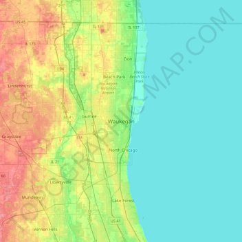
Nombre: Mapa topográfico Waukegan, altitud, relieve.
Lugar: Waukegan, Lake County, Illinois, 60085, United States (42.20363 -88.00479 42.52363 -87.68479)
Altitud media: 200 m
Altitud mínima: 173 m
Altitud máxima: 270 m
Waukegan is located at 42°22′13″N 87°52′16″W / 42.37028°N 87.87111°W / 42.37028; -87.87111 (42.3703140, −87.8711404). Waukegan is on the shore of Lake Michigan, about 11 miles (18 km) south of the border with Wisconsin and 41 miles (66 km) north of downtown Chicago, at an elevation of about 650 feet (200 m) above sea level.
Otros mapas topográficos
Haga clic en un mapa para ver su topografía, su altitud y su relieve.
Spaulding Corners
United States > Illinois > Lake County > Waukegan
Spaulding Corners, Waukegan, Lake County, Illinois, 60085, United States
Altitud media: 214 m