
Mapa topográfico Wake County
Mapa interactivo
Haga clic en el mapa para ver la altitud.
Acerca de este mapa
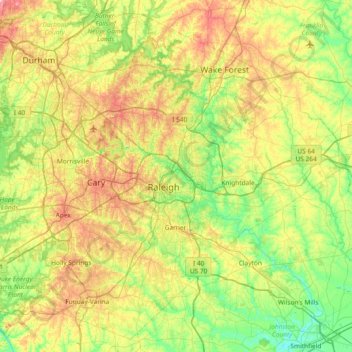
Nombre: Mapa topográfico Wake County, altitud, relieve.
Lugar: Wake County, North Carolina, United States of America (35.51941 -78.99505 36.07654 -78.25368)
Altitud media: 96 m
Altitud mínima: 30 m
Altitud máxima: 218 m
Wake County is located in the northeast central region of North Carolina, where the North American Piedmont and Atlantic Coastal Plain regions meet. This area is known as the "fall line" because it marks the elevation inland at which waterfalls begin to appear in creeks and rivers. As a result, most of Wake County features gently rolling hills that slope eastward toward the state's flat coastal plain. Its central Piedmont location situates the county about three hours west of Atlantic Beach, North Carolina, by car and four hours east of the Great Smoky Mountains.
Otros mapas topográficos
Haga clic en un mapa para ver su topografía, su altitud y su relieve.
Mecklenburg County
United States of America > North Carolina
Mecklenburg County, North Carolina, United States of America
Altitud media: 208 m
Graham County
United States of America > North Carolina
Graham County, North Carolina, United States of America
Altitud media: 850 m
Davidson County
United States of America > North Carolina
Davidson County, North Carolina, United States of America
Altitud media: 222 m
Yancey County
United States of America > North Carolina
Yancey County, North Carolina, United States of America
Altitud media: 969 m