
Gracias por apoyar a este sitio ❤️
Haz una donación
Haz una donación
Mapa topográfico Tsimkoura
Haga clic en el mapa para ver la altitud.
Gracias por apoyar a este sitio ❤️
Haz una donación
Haz una donación
Acerca de este mapa
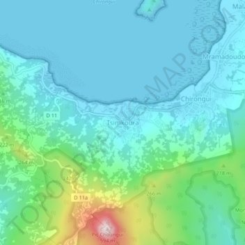
Nombre: Mapa topográfico Tsimkoura, altitud, relieve.
Lugar: Tsimkoura, Chirongui, Mayotte, 97620, France (-12.95939 45.11689 -12.91939 45.15689)
Altitud media: 93 m
Altitud mínima: 0 m
Altitud máxima: 504 m
Gracias por apoyar a este sitio ❤️
Haz una donación
Haz una donación
Otros mapas topográficos
Haga clic en un mapa para ver su topografía, su altitud y su relieve.
Gracias por apoyar a este sitio ❤️
Haz una donación
Haz una donación
Gracias por apoyar a este sitio ❤️
Haz una donación
Haz una donación
Mtsamboro
The village of Mtsamboro lies on the northwest coast of the island along National Road 1. To the northeast is the village of Mtsahara and to the southwest is Mtsangadoua. Two small peninsulas jut out in the village area, the larger of which lies roughly a mile north of the village centre and separates the main…
Altitud media: 48 m
Gracias por apoyar a este sitio ❤️
Haz una donación
Haz una donación