
Mapa topográfico Rügen
Mapa interactivo
Haga clic en el mapa para ver la altitud.
Acerca de este mapa
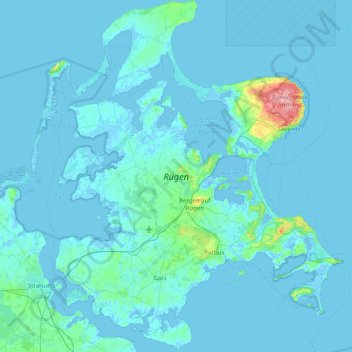
Nombre: Mapa topográfico Rügen, altitud, relieve.
Altitud media: 7 m
Altitud mínima: -5 m
Altitud máxima: 163 m
Rügen has a total area of 926.4 km2 (357.7 sq mi), or 974 km2 (376 sq mi) if the adjacent small islands are included. The maximum diameter is 51.4 km (31.9 mi) from north to south, and 42.8 km (26.6 mi) from east to west. Of an overall 574 km (357 mi)-long coastline, 56 km (35 mi) are sandy Baltic Sea beaches, and 2.8 km (1.7 mi) sandy bodden beaches. The highest elevations are on the Jasmund peninsula: Piekberg (161 m (528 ft)) and Königsstuhl (117 m (384 ft)).