
Mapa topográfico Ribeira da Janela
Mapa interactivo
Haga clic en el mapa para ver la altitud.
Acerca de este mapa
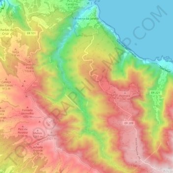
Nombre: Mapa topográfico Ribeira da Janela, altitud, relieve.
Lugar: Ribeira da Janela, Porto Moniz, Madeira, 9270, Portugal (32.76715 -17.17608 32.85736 -17.10635)
Altitud media: 713 m
Altitud mínima: -1 m
Altitud máxima: 1.461 m
It is located northeast coast of the municipality of Porto Moniz, connected by the main roadway that circles the island to the principal communities in Funchal and Calheta. Mountainous, the parish is cut by several river valleys extending into the Atlantic Ocean from the interior plateau of Paul da Serra, where it borders the municipalities of Ponta do Sol and Calheta. The ravine, Ribeira da Janela, meanders through the parish from Paul da Serra (springing from the plateau at around 1,420 metres altitude) and flows at various intervals along the water course. The valley cut by this ravine is one of the longest in Madeira. Forests dominate the northern and the western parts of the valley and while brush characterises the remaining areas.
Otros mapas topográficos
Haga clic en un mapa para ver su topografía, su altitud y su relieve.