
Haz una donación
Mapa topográfico Half Dome
Haga clic en el mapa para ver la altitud.
Haz una donación
Half Dome
The Half Dome Cable Route hike runs from the valley floor to the top of the dome in 8.2 mi (13 km) (via the Mist Trail), with 4,800 ft (1,460 m) of elevation gain. The length and difficulty of the trail used to keep it less crowded than other park trails, but trail traffic grew to as many as 1,000 people a day, and about 50,000 per year, before a permit system was introduced in 2010. The hike can be done from the valley floor in a single long day, but many people break it up by camping overnight in Little Yosemite Valley. The trail climbs past Vernal Fall and Nevada Fall, then continues into Little Yosemite Valley, then north to the base of the northeast ridge of Half Dome itself.
Haz una donación
Acerca de este mapa
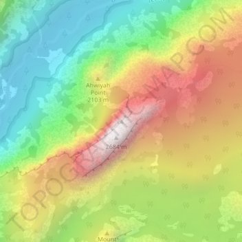
Nombre: Mapa topográfico Half Dome, altitud, relieve.
Lugar: Half Dome, Mariposa County, California, United States (37.74595 -119.53330 37.74605 -119.53320)
Altitud media: 1.887 m
Altitud mínima: 1.241 m
Altitud máxima: 2.693 m
Haz una donación
Otros mapas topográficos
Haga clic en un mapa para ver su topografía, su altitud y su relieve.
Yosemite Valley
United States > California > Mariposa County > Yosemite Village
Altitud media: 2.016 m
Echo Valley
United States > California > Mariposa County
Echo Valley is a valley in Yosemite National Park, at an elevation of 7,021 feet (2,140 m). It is located along Echo Creek, about 3 miles (5 km) west of Merced Lake, at 37°44′38″N 119°26′03″W / 37.7438°N 119.4343°W / 37.7438; -119.4343. It is bounded on the south by the Merced River.
Altitud media: 2.333 m
Haz una donación
Yosemite Valley
United States > California > Mariposa County > Yosemite Village
Altitud media: 2.012 m
Yosemite Valley
United States > California > Mariposa County > Yosemite Village
Altitud media: 2.016 m