
Haz una donación
Mapa topográfico Douro-Dummer
Haga clic en el mapa para ver la altitud.
Haz una donación
Acerca de este mapa
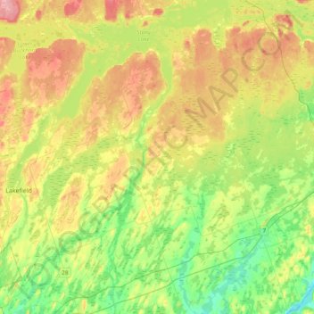
Nombre: Mapa topográfico Douro-Dummer, altitud, relieve.
Altitud media: 237 m
Altitud mínima: 182 m
Altitud máxima: 316 m
Haz una donación
Otros mapas topográficos
Haga clic en un mapa para ver su topografía, su altitud y su relieve.
Millbrook
Canada > Ontario > Peterborough County > Cavan-Monaghan
Peterborough's topography is largely defined by land formations created by the receding Wisconsian glaciers 10,000–15,000 years ago. The South End and Downtown portions of the city sit on what was the bottom of the glacial Lake Peterborough—part of a glacial spillway created when glacial meltwaters from…
Altitud media: 250 m
Haz una donación
Mount Pleasant
Canada > Ontario > Peterborough County > Cavan-Monaghan > Mount Pleasant
Altitud media: 280 m
Haz una donación
Haz una donación
Haz una donación
Villiers
Canada > Ontario > Peterborough County > Otonabee–South Monaghan > Villiers
Altitud media: 225 m
Haz una donación
Haz una donación
Millbrook
Canada > Ontario > Peterborough County > Cavan-Monaghan
Peterborough's topography is largely defined by land formations created by the receding Wisconsian glaciers 10,000–15,000 years ago. The South End and Downtown portions of the city sit on what was the bottom of the glacial Lake Peterborough—part of a glacial spillway created when glacial meltwaters from…
Altitud media: 250 m