
Mapa topográfico Deltona
Mapa interactivo
Haga clic en el mapa para ver la altitud.
Deltona
The majority of the land in the city is of karst topography, characterized by rolling hills and an abundant amount of lakes. The St. Johns River passes through Lake Monroe, directly south of the city. The United States Geological Survey lists the city's elevation at 33 feet (10 m) above sea level at a point near Deltona's geographic center. Elevations range from 20 feet (6.1 m) to 112 feet (34 m) above sea level. As of 2010, according to the United States Census Bureau, the city has a total area of 41.1 square miles (106.4 km2), 37.5 square miles (97.1 km2) of which is land and 3.5 square miles (9.1 km2) of which is water.
Acerca de este mapa
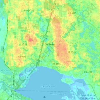
Nombre: Mapa topográfico Deltona, altitud, relieve.
Lugar: Deltona, Volusia County, Florida, United States (28.82107 -81.28243 28.96365 -81.15004)
Altitud media: 12 m
Altitud mínima: -3 m
Altitud máxima: 37 m
Otros mapas topográficos
Haga clic en un mapa para ver su topografía, su altitud y su relieve.
Samsula-Spruce Creek
United States > Florida > Volusia County > New Smyrna Beach > South Village
Altitud media: 8 m