
Mapa topográfico Dhamtari
Mapa interactivo
Haga clic en el mapa para ver la altitud.
Acerca de este mapa
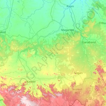
Nombre: Mapa topográfico Dhamtari, altitud, relieve.
Lugar: Dhamtari, Chhattisgarh, India (20.04411 81.40997 21.02665 82.18057)
Altitud media: 409 m
Altitud mínima: 273 m
Altitud máxima: 849 m
Otros mapas topográficos
Haga clic en un mapa para ver su topografía, su altitud y su relieve.
Kharsia
India > Chhattisgarh > Kharsia Tahsil
Kharsia is located at 21°58′N 83°07′E / 21.97°N 83.12°E / 21.97; 83.12. It has an average elevation of 245 m (804 ft).
Altitud media: 253 m
Balod
India > Chhattisgarh > Balod Tahsil
Balod is located at 20°44′N 81°12′E / 20.73°N 81.2°E / 20.73; 81.2. It has an average elevation of 324 metres (1063 feet).
Altitud media: 323 m
Kanker
India > Chhattisgarh > Kanker Tahsil
Kanker is located at 20°16′N 81°29′E / 20.27°N 81.49°E / 20.27; 81.49. It has an average elevation of 388 metres (1272 feet).
Altitud media: 405 m
Kanker
India > Chhattisgarh > Kanker Tahsil
Kanker is located at 20°16′N 81°29′E / 20.27°N 81.49°E / 20.27; 81.49. It has an average elevation of 388 metres (1272 feet).
Altitud media: 405 m
Raigarh
India > Chhattisgarh > Raigarh Tahsil
Raigarh is located at 21°54′N 83°24′E / 21.9°N 83.4°E / 21.9; 83.4. It has an average elevation of 215 metres (705 feet). The Kelo river flows through the city, which is one of its main water sources.
Altitud media: 216 m
Gariaband
India > Chhattisgarh > Bindranavagarh(Gariyaband) Tahsil
Gariaband is Loceted on 20°38′N 82°03′E / 20.63°N 82.05°E / 20.63; 82.05. Gariaband has an average elevation of 318 metres (1043 ft).
Altitud media: 346 m
Kanker
India > Chhattisgarh > Kanker Tahsil
Kanker is located at 20°16′N 81°29′E / 20.27°N 81.49°E / 20.27; 81.49. It has an average elevation of 388 metres (1272 feet).
Altitud media: 405 m
Sukma
India > Chhattisgarh > Sukma Tahsil
It is located at 18°24′0″N 81°40′0″E / 18.40000°N 81.66667°E / 18.40000; 81.66667 at an elevation of 210 m above MSL.
Altitud media: 219 m
Champa
India > Chhattisgarh > Champa Tahsil
Champa has an average elevation of 253 metres (830 feet). It is located on the banks of Hasdeo river, a tributary of Mahanadi.
Altitud media: 254 m
Kapsi
India > Chhattisgarh > Pakhanjur Tahsil
Geographically, it lies in the northern lowlands of the Bastar plateau and is a part of the historical Dandakaranya region. The elevation of the village ranges from 310 m (1,020 ft) to 330 m (1,080 ft) above sea level. The Devda ravine, a tributary of Kotri river, meanders through the heart of the village and…
Altitud media: 325 m
Balodabazar
India > Chhattisgarh > Baloda Bazar Tahsil
Baloda Bazar is located at 30°40′N 82°10′E / 30.67°N 82.17°E / 30.67; 82.17. It has an average elevation of 254 m (833 ft). There are several tourist places in Balodabazaar like Sirpur, Turturia, Giroudpuri, Siddheswr Mandir Pallari and many more.
Altitud media: 251 m
Bhilai
India > Chhattisgarh > Durg Tahsil
Bhilai lies at 21.21°N 81.38°E in Central India at an elevation of 297m above sea level on the banks of the Shivnath river, a tributary of the river Mahanadi. It covers an area of 341 km2 (132 sq mi).
Altitud media: 292 m
Kirandul
India > Chhattisgarh > Kuakonda Tahsil
The Kothavalasa–Kirandul line of East Coast Railway from Kirandul to Visakhapatnam via Koraput is laid through the Eastern Ghats. Up to Araku station, it has many tunnels. Also it pass through the highest elevation Broad gauge station in the Eastern ghats, Semiliguda, just before the Borra caves. Kirandul -…
Altitud media: 742 m
Pendra
India > Chhattisgarh > Pendra Tahsil
Pendra has an average elevation of 617 metres (2,024 ft).
Altitud media: 594 m
Bhatpara
India > Chhattisgarh > Bhatpara
Bhatpara is located at 22°52′N 88°25′E / 22.87°N 88.41°E / 22.87; 88.41. It has an average elevation of 12 metres (39 feet). The main town is sandwiched between the Hoogly river in the west and railway track linking Sealdah and Krishnanagar in the east.
Altitud media: 264 m