
Mapa topográfico Craven County
Mapa interactivo
Haga clic en el mapa para ver la altitud.
Acerca de este mapa
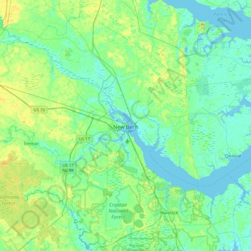
Nombre: Mapa topográfico Craven County, altitud, relieve.
Lugar: Craven County, North Carolina, United States (34.80893 -77.47372 35.41837 -76.65257)
Altitud media: 8 m
Altitud mínima: -9 m
Altitud máxima: 39 m
Otros mapas topográficos
Haga clic en un mapa para ver su topografía, su altitud y su relieve.
Highlands
United States > North Carolina > Macon County > Highlands
Highlands was founded in 1875 after its two founders, Samuel Truman Kelsey and Clinton Carter Hutchinson, drew lines from Chicago to Savannah and from New Orleans to New York City. They felt that the place where these lines met would eventually become a great trading center and commercial crossroads. Highlands…
Altitud media: 1.090 m
Appalachian Mountains
United States > North Carolina > Yancey County
The Appalachian Mountains (French: Appalaches), often called the Appalachians, are a system of mountains in eastern to northeastern North America. The Appalachians first formed roughly 480 million years ago during the Ordovician Period. They once reached elevations similar to those of the Alps and the Rocky…
Altitud media: 1.463 m
Ballantyne's Backyard
United States > North Carolina > Mecklenburg County > Charlotte
Altitud media: 183 m
Appalachian Mountains
United States > North Carolina > Yancey County
The Appalachian Mountains (French: Appalaches), often called the Appalachians, are a system of mountains in eastern to northeastern North America. The Appalachians first formed roughly 480 million years ago during the Ordovician Period. They once reached elevations similar to those of the Alps and the Rocky…
Altitud media: 1.463 m
Boiling Spring Lake Dam
United States > North Carolina > Brunswick County > Boiling Spring Lakes
Altitud media: 14 m
Country Club Estates
United States > North Carolina > Alamance County > Burlington
Altitud media: 195 m
Maplewood
United States > North Carolina > Richmond County > Rockingham > East Rockingham
Altitud media: 83 m
Mount Mitchell
United States > North Carolina > Yancey County
Mount Mitchell (Attakulla in Cherokee) is the highest peak of the Appalachian Mountains and the highest peak in mainland North America east of the Mississippi River. It is located near Burnsville in Yancey County, North Carolina in the Black Mountain subrange of the Appalachians about 19 miles (31 km)…
Altitud media: 1.743 m
Mount Mitchell
United States > North Carolina > Yancey County
Mount Mitchell, known in Cherokee as Attakulla, is the highest peak of the Appalachian Mountains and the highest peak in mainland eastern North America. It is located near Burnsville in Yancey County, North Carolina in the Black Mountain subrange of the Appalachians about 19 miles (31 km) northeast of…
Altitud media: 1.743 m
Bald Head Island
United States > North Carolina > Brunswick County > Bald Head Island
Altitud media: 3 m