
Mapa topográfico New York
Mapa interactivo
Haga clic en el mapa para ver la altitud.
Acerca de este mapa
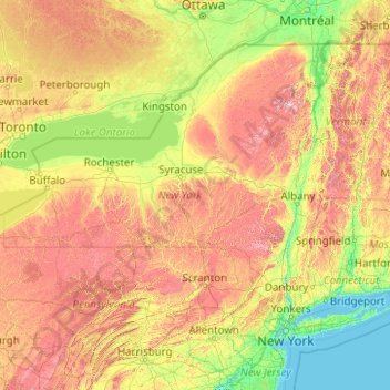
Nombre: Mapa topográfico New York, altitud, relieve.
Lugar: New York, United States (40.47658 -79.76198 45.01586 -71.79097)
Altitud media: 278 m
Altitud mínima: -2 m
Altitud máxima: 1.436 m
New York has a diverse geography. The southeastern part of the state, the area known as Downstate, includes Long Island and several smaller associated islands, as well as New York City and the lower Hudson River Valley. The much larger Upstate New York area spreads from the Great Lakes to Lake Champlain, while its Southern tier region extends to the border of Pennsylvania; Upstate includes a diverse topography and range of regions including the Adirondack Mountains in the northeastern lobe of the state and the Catskill Mountains in the southwestern part of the state. New York also includes several ranges of the wider Appalachian Mountains. The east–west Mohawk River Valley is the primary river valley bisecting more mountainous regions, and connects to the north-south Hudson River valley in the Capital Region of New York. Western New York is part of the Great Lakes region and borders the Great Lakes of Lake Ontario and Lake Erie, as well as Niagara Falls. Between the central and western parts of the state, New York is dominated by the Finger Lakes, a popular vacation and tourist destination.
Otros mapas topográficos
Haga clic en un mapa para ver su topografía, su altitud y su relieve.
Albuquerque
United States > New Mexico > Bernalillo County
Albuquerque, Bernalillo County, New Mexico, United States
Altitud media: 1.688 m
Bonita Springs
United States > Florida > Lee County
Bonita Springs, Lee County, Florida, United States
Altitud media: 5 m
Annapolis
United States > Maryland > Anne Arundel County
Annapolis, Anne Arundel County, Maryland, United States
Altitud media: 8 m
Brooklyn
United States > New York > New York
Brooklyn, Kings County, New York, United States
Altitud media: 9 m
Allegheny County
Allegheny County, Pennsylvania, United States
Altitud media: 325 m
Jacksonville
United States > Florida > Duval County
Jacksonville, Duval County, Florida, United States
Altitud media: 10 m
Montgomery County
Montgomery County, Pennsylvania, United States
Altitud media: 109 m
Knoxville
United States > Tennessee > Knox County
Knoxville, Knox County, East Tennessee, Tennessee, United States
Altitud media: 307 m
Waltham
United States > Massachusetts > Middlesex County
Waltham, Middlesex County, Massachusetts, United States
Altitud media: 48 m
Eau Claire County
Eau Claire County, Wisconsin, United States
Altitud media: 304 m
Stamford
United States > Connecticut > Western Connecticut Planning Region
Stamford, Western Connecticut Planning Region, Connecticut, United States
Altitud media: 48 m
Houston
United States > Texas > Harris County
Houston, Harris County, Texas, United States
Altitud media: 25 m
Santa Cruz
United States > California > Santa Cruz County
Santa Cruz, Santa Cruz County, California, United States
Altitud media: 89 m
Texas City
United States > Texas > Galveston County
Texas City, Galveston County, Texas, United States
Altitud media: 2 m
Yosemite National Park
Yosemite National Park, California, United States
Altitud media: 2.337 m
Appalachian Mountains
United States > North Carolina > Yancey County
Appalachian Mountains, Yancey County, North Carolina, United States
Altitud media: 1.463 m
Aurora
United States > Colorado > Adams County
Aurora, Adams County, Colorado, United States
Altitud media: 1.691 m
Boulder
United States > Colorado > Boulder County
Boulder, Boulder County, Colorado, United States
Altitud media: 1.785 m