
Gracias por apoyar a este sitio ❤️
Haz una donación
Haz una donación
Mapa topográfico Enosburgh
Haga clic en el mapa para ver la altitud.
Gracias por apoyar a este sitio ❤️
Haz una donación
Haz una donación
Acerca de este mapa
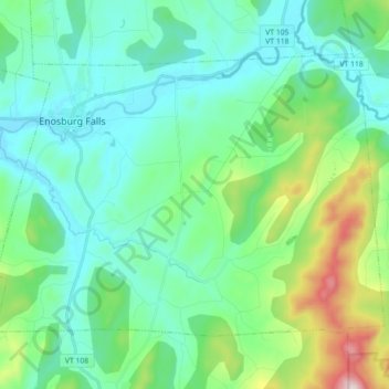
Nombre: Mapa topográfico Enosburgh, altitud, relieve.
Lugar: Enosburgh, Franklin County, Vermont, United States (44.83681 -72.83948 44.92844 -72.66155)
Altitud media: 246 m
Altitud mínima: 109 m
Altitud máxima: 761 m
Gracias por apoyar a este sitio ❤️
Haz una donación
Haz una donación
Otros mapas topográficos
Haga clic en un mapa para ver su topografía, su altitud y su relieve.
Gracias por apoyar a este sitio ❤️
Haz una donación
Haz una donación
Gracias por apoyar a este sitio ❤️
Haz una donación
Haz una donación
Sheldon Springs
United States > Vermont > Franklin County > Sheldon
Sheldon Springs is an unincorporated community village in the town of Sheldon in Franklin County, Vermont, United States. It lies at an altitude of 299 feet (91 m). A post office was established in 1871.
Altitud media: 118 m
Gracias por apoyar a este sitio ❤️
Haz una donación
Haz una donación