
Gracias por apoyar a este sitio ❤️
Haz una donación
Haz una donación
Mapa topográfico La Ferandière
Haga clic en el mapa para ver la altitud.
Gracias por apoyar a este sitio ❤️
Haz una donación
Haz una donación
Acerca de este mapa
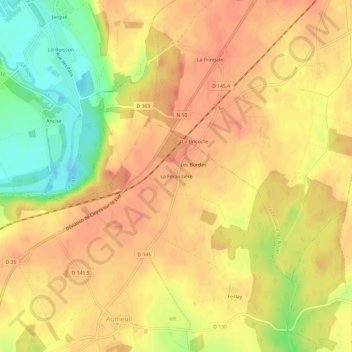
Nombre: Mapa topográfico La Ferandière, altitud, relieve.
Altitud media: 129 m
Altitud mínima: 96 m
Altitud máxima: 143 m
Gracias por apoyar a este sitio ❤️
Haz una donación
Haz una donación
Otros mapas topográficos
Haga clic en un mapa para ver su topografía, su altitud y su relieve.
Saint-Hilaire-sur-Yerre
France > Centre-Val de Loire > Eure-et-Loir > Cloyes-les-Trois-Rivières
Altitud media: 135 m
La Ferté-Villeneuil
France > Centre-Val de Loire > Eure-et-Loir > Cloyes-les-Trois-Rivières
Altitud media: 122 m
Gracias por apoyar a este sitio ❤️
Haz una donación
Haz una donación
Romilly-sur-Aigre
France > Centre-Val de Loire > Eure-et-Loir > Cloyes-les-Trois-Rivières
Altitud media: 118 m
Cloyes-sur-le-Loir
France > Centre-Val de Loire > Eure-et-Loir > Cloyes-les-Trois-Rivières
Altitud media: 127 m