Geolocalizar

Mapa topográfico Charray

Mapa interactivo

Haga clic en el mapa para ver la altitud.

Acerca de este mapa

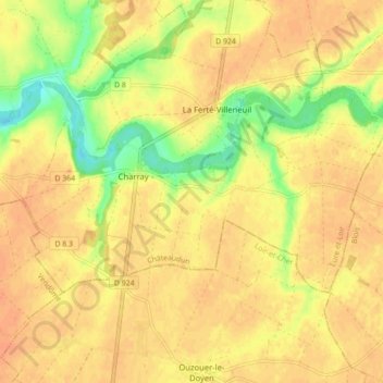
Nombre: Mapa topográfico Charray, altitud, relieve.

Lugar: Charray, Cloyes-les-Trois-Rivières, Châteaudun, Eure-et-Loir, Centre-Val de Loire, France métropolitaine, 28220, France (47.95402 1.29958 47.98487 1.38711)

Altitud media: 124 m

Altitud mínima: 97 m

Altitud máxima: 136 m

Otros mapas topográficos

Haga clic en un mapa para ver su topografía, su altitud y su relieve.

Romilly-sur-Aigre

France > Centre-Val de Loire > Eure-et-Loir > Cloyes-les-Trois-Rivières

Romilly-sur-Aigre, Cloyes-les-Trois-Rivières, Châteaudun, Eure-et-Loir, Centre-Val de Loire, France métropolitaine, 28220, France

Altitud media: 118 m

Autheuil

France > Centre-Val de Loire > Eure-et-Loir > Cloyes-les-Trois-Rivières

Autheuil, Cloyes-les-Trois-Rivières, Châteaudun, Eure-et-Loir, Centre-Val de Loire, France métropolitaine, 28220, France

Altitud media: 123 m

Saint-Hilaire-sur-Yerre

France > Centre-Val de Loire > Eure-et-Loir > Cloyes-les-Trois-Rivières

Saint-Hilaire-sur-Yerre, Cloyes-les-Trois-Rivières, Châteaudun, Eure-et-Loir, Centre-Val de Loire, France métropolitaine, 28220, France

Altitud media: 135 m

Cloyes-sur-le-Loir

France > Centre-Val de Loire > Eure-et-Loir > Cloyes-les-Trois-Rivières

Cloyes-sur-le-Loir, Cloyes-les-Trois-Rivières, Châteaudun, Eure-et-Loir, Centre-Val de Loire, France métropolitaine, 28220, France

Altitud media: 127 m

La Ferandière

France > Centre-Val de Loire > Eure-et-Loir > Cloyes-les-Trois-Rivières

La Ferandière, Autheuil, Cloyes-les-Trois-Rivières, Châteaudun, Eure-et-Loir, Centre-Val de Loire, France métropolitaine, 28220, France

Altitud media: 129 m