
Mapa topográfico Bahour Taluk
Haga clic en el mapa para ver la altitud.
Acerca de este mapa
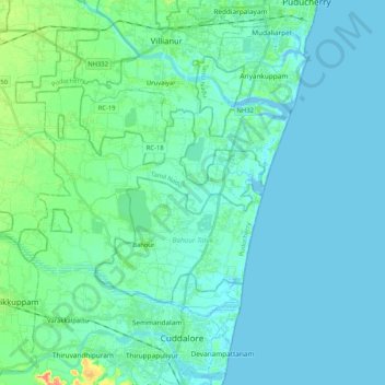
Nombre: Mapa topográfico Bahour Taluk, altitud, relieve.
Lugar: Bahour Taluk, Puducherry District, Puducherry, India (11.77523 79.59942 11.89131 79.80680)
Altitud media: 7 m
Altitud mínima: -5 m
Altitud máxima: 44 m
Otros mapas topográficos
Haga clic en un mapa para ver su topografía, su altitud y su relieve.
Puducherry
India > Puducherry > Puducherry Taluk
The topography of Pondicherry is the same as that of coastal Tamil Nadu. Pondicherry's average elevation is at sea level and includes a number of sea inlets, referred to locally as "backwaters". Pondicherry experiences extreme coastal erosion as a result of a breakwater constructed in 1989, just to the south…
Altitud media: 10 m