
Gracias por apoyar a este sitio ❤️
Haz una donación
Haz una donación
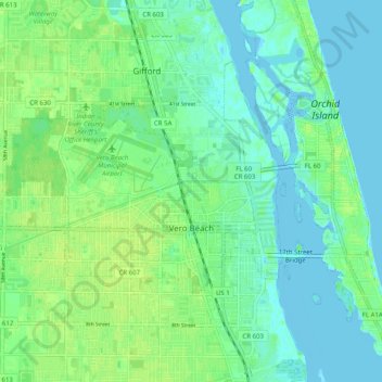
Mapa topográfico Vero Beach
Haga clic en el mapa para ver la altitud.
Gracias por apoyar a este sitio ❤️
Haz una donación
Haz una donación
Vero Beach
Like much of Florida, Vero Beach is mostly flat, stretching from the beach and running inland. The average elevation of the city is 23 feet above sea level.
Gracias por apoyar a este sitio ❤️
Haz una donación
Haz una donación
Acerca de este mapa
Nombre: Mapa topográfico Vero Beach, altitud, relieve.
Lugar: Vero Beach, Indian River County, Florida, United States (27.61697 -80.44642 27.67754 -80.34630)
Altitud media: 6 m
Altitud mínima: -4 m
Altitud máxima: 14 m
Gracias por apoyar a este sitio ❤️
Haz una donación
Haz una donación
Otros mapas topográficos
Haga clic en un mapa para ver su topografía, su altitud y su relieve.
Gracias por apoyar a este sitio ❤️
Haz una donación
Haz una donación
Gracias por apoyar a este sitio ❤️
Haz una donación
Haz una donación