
Mapa topográfico Florida Ridge
Haga clic en el mapa para ver la altitud.
Acerca de este mapa
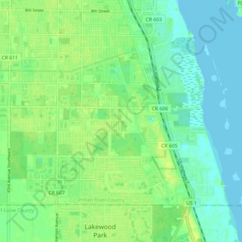
Nombre: Mapa topográfico Florida Ridge, altitud, relieve.
Altitud media: 7 m
Altitud mínima: -1 m
Altitud máxima: 14 m
Otros mapas topográficos
Haga clic en un mapa para ver su topografía, su altitud y su relieve.
Vero Beach
United States > Florida > Indian River County
Vero Beach, located along Florida's Atlantic coast, features relatively flat and low-lying terrain. The area has an average elevation of around 25 feet above sea level, with the highest point reaching about 40 feet. This coastal region is predominantly characterized by sandy beaches and wetlands, interspersed…
Altitud media: 6 m
Vero Beach
United States > Florida > Indian River County
Like much of Florida, Vero Beach is mostly flat, stretching from the beach and running inland. The average elevation of the city is 23 feet above sea level.
Altitud media: 6 m
Vero Beach
United States > Florida > Indian River County
Like much of Florida, Vero Beach is mostly flat, stretching from the beach and running inland. The average elevation of the city is 23 feet above sea level.
Altitud media: 6 m
Vero Beach
United States > Florida > Indian River County
Like much of Florida, Vero Beach is mostly flat, stretching from the beach and running inland. The average elevation of the city is 23 feet above sea level.
Altitud media: 6 m