
Mapa topográfico Empire Township
Mapa interactivo
Haga clic en el mapa para ver la altitud.
Acerca de este mapa
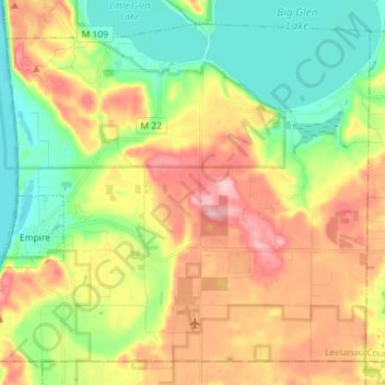
Nombre: Mapa topográfico Empire Township, altitud, relieve.
Lugar: Empire Township, Leelanau County, Michigan, United States (44.77831 -86.07863 44.86737 -85.93555)
Altitud media: 244 m
Altitud mínima: 170 m
Altitud máxima: 342 m
Otros mapas topográficos
Haga clic en un mapa para ver su topografía, su altitud y su relieve.
Lake Leelanau
United States > Michigan > Leelanau County
Lake Leelanau, Leland Township, Leelanau County, Michigan, 49653, United States
Altitud media: 210 m
Northport
United States > Michigan > Leelanau County
Northport, Leelanau Township, Leelanau County, Michigan, 49670, United States
Altitud media: 193 m
Suttons Bay Township
United States > Michigan > Leelanau County
Suttons Bay Township, Leelanau County, Michigan, United States
Altitud media: 221 m
Glen Arbor
United States > Michigan > Leelanau County
Glen Arbor, Glen Arbor Township, Leelanau County, Michigan, 49636, United States
Altitud media: 194 m
Sleeping Bear Dunes National Lakeshore
United States > Michigan > Leelanau County
Sleeping Bear Dunes National Lakeshore, Leelanau County, Michigan, 49636, United States
Altitud media: 204 m
Sleeping Bear Dunes
United States > Michigan > Leelanau County
Sleeping Bear Dunes, Glen Arbor Township, Leelanau County, Michigan, United States
Altitud media: 231 m