Geolocalizar

Mapa topográfico Hagerstown

Mapa interactivo

Haga clic en el mapa para ver la altitud.

Acerca de este mapa

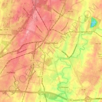
Nombre: Mapa topográfico Hagerstown, altitud, relieve.

Lugar: Hagerstown, Washington County, Maryland, United States (39.60003 -77.77309 39.67373 -77.67228)

Altitud media: 170 m

Altitud mínima: 102 m

Altitud máxima: 204 m

Hagerstown has a distinct topography, formed by stone ridges running from northeast to southwest through the center of town. Geography accordingly bounds its neighborhoods. These ridges consist of upper Stonehenge limestone. Many of the older buildings were built from this stone, which is easily quarried and dressed onsite. It whitens in weathering and the edgewise conglomerate and wavy laminae become distinctly visible, giving a handsome and uniquely "Cumberland Valley" appearance. Several of Hagerstown's churches are constructed of Stonehenge limestone. Its value and beauty as building rock may be seen particularly in St. John's Episcopal Church on West Antietam Street and the Presbyterian Church at the corner of Washington and Prospect Streets. Brick and concrete eventually displaced this native stone in the construction process.

Wikipedia (CC-BY-SA 3.0)

Otros mapas topográficos

Haga clic en un mapa para ver su topografía, su altitud y su relieve.

Antietam

United States > Maryland > Washington County

Antietam, Washington County, Maryland, 21782, United States

Altitud media: 123 m

Keedysville

United States > Maryland > Washington County

Keedysville, Washington County, Maryland, United States

Altitud media: 129 m

Weverton

United States > Maryland > Washington County

Weverton, Washington County, Maryland, 21758, United States

Altitud media: 153 m

Halfway

United States > Maryland > Washington County

Halfway, Washington County, Maryland, United States

Altitud media: 171 m

Williamsport

United States > Maryland > Washington County

Williamsport, Washington County, Maryland, United States

Altitud media: 127 m

Robinwood

United States > Maryland > Washington County > Robinwood

Robinwood, Washington County, Maryland, United States

Altitud media: 175 m

Cavetown

United States > Maryland > Washington County

Cavetown, Washington County, Maryland, 21720, United States

Altitud media: 259 m

Wilson-Conococheague

United States > Maryland > Washington County

Wilson-Conococheague, Washington County, Maryland, United States

Altitud media: 140 m

Paramount-Long Meadow

United States > Maryland > Washington County > Paramount

Paramount-Long Meadow, Paramount, Washington County, Maryland, 21742, United States

Altitud media: 177 m

Cascade

United States > Maryland > Washington County

Cascade, Washington County, Maryland, 21719, United States

Altitud media: 436 m

Antietam National Battlefield

United States > Maryland > Washington County > Sharpsburg

Antietam National Battlefield, Sharpsburg, Washington County, Maryland, 21782, United States

Altitud media: 147 m

Big Pool Lake

United States > Maryland > Washington County > Big Pool

Big Pool Lake, Big Pool, Washington County, Maryland, United States

Altitud media: 143 m

Saint James Village

United States > Maryland > Washington County

Saint James Village, Washington County, Maryland, 21746, United States

Altitud media: 154 m

Sharpsburg

United States > Maryland > Washington County

Sharpsburg, Washington County, Maryland, United States

Altitud media: 138 m

Pleasant Valley

United States > Maryland > Washington County

Pleasant Valley, Washington County, Maryland, 21783, United States

Altitud media: 462 m

Smithsburg

United States > Maryland > Washington County

Smithsburg, Washington County, Maryland, 21783, United States

Altitud media: 244 m

Dargan

United States > Maryland > Washington County

Dargan, Washington County, Maryland, 21782, United States

Altitud media: 158 m

Mount Lena

United States > Maryland > Washington County > Mount Lena

Mount Lena, Washington County, Maryland, United States

Altitud media: 243 m

Hancock

United States > Maryland > Washington County > Hancock > Hancock

Hancock, Washington County, Maryland, 21750, United States

Altitud media: 166 m

Hillside

United States > Maryland > Washington County > Hillside

Hillside, Washington County, Maryland, United States

Altitud media: 181 m

Greenbrier State Park

United States > Maryland > Washington County > San Mar

Greenbrier State Park, Mountain Laurel Road, San Mar, Washington County, Maryland, 21713, United States

Altitud media: 305 m

Boonsboro

United States > Maryland > Washington County

Boonsboro, Washington County, Maryland, 21713, United States

Altitud media: 193 m

Clear Spring

United States > Maryland > Washington County

Clear Spring, Washington County, Maryland, United States

Altitud media: 176 m

Hancock

United States > Maryland > Washington County

Hancock, Washington County, Maryland, 21750, United States

Altitud media: 167 m

Bakersville

United States > Maryland > Washington County

Bakersville, Washington County, Maryland, 21733, United States

Altitud media: 137 m