
Haz una donación
Mapa topográfico Downsville
Haga clic en el mapa para ver la altitud.
Haz una donación
Acerca de este mapa
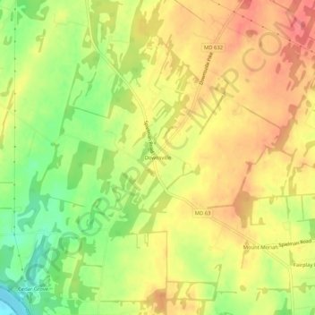
Nombre: Mapa topográfico Downsville, altitud, relieve.
Altitud media: 141 m
Altitud mínima: 102 m
Altitud máxima: 168 m
Haz una donación
Otros mapas topográficos
Haga clic en un mapa para ver su topografía, su altitud y su relieve.
Hagerstown
United States > Maryland > Washington County
Hagerstown has a distinct topography, formed by stone ridges running from northeast to southwest through the center of town. Geography accordingly bounds its neighborhoods. These ridges consist of upper Stonehenge limestone. Many of the older buildings were built from this stone, which is easily quarried and…
Altitud media: 170 m
Haz una donación
Antietam National Battlefield
United States > Maryland > Washington County > Sharpsburg
Altitud media: 147 m
Haz una donación
Hagerstown
United States > Maryland > Washington County
Hagerstown has a distinct topography, formed by stone ridges running from northeast to southwest through the center of town. Geography accordingly bounds its neighborhoods. These ridges consist of upper Stonehenge Limestone. Many of the older buildings were built from this stone, which is easily quarried and…
Altitud media: 170 m
Haz una donación
South Mountain State Park
United States > Maryland > Washington County > Mount Lena
Altitud media: 201 m
Haz una donación