
Haz una donación
Mapa topográfico Erving
Haga clic en el mapa para ver la altitud.
Haz una donación
Erving
The town is home to a number of topographic features popular among outdoor recreation enthusiasts. Erving State Forest has recreation and seasonal camping facilities. The Millers River is used for fishing and whitewater kayaking. Northfield Mountain hosts cross country ski trails, hiking trails, and rock climbing ascents, including the 114 mile (183 km) Metacomet-Monadnock Trail and the Farley Ledges rock climbing area.
Haz una donación
Acerca de este mapa
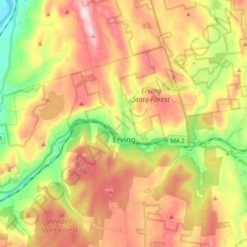
Nombre: Mapa topográfico Erving, altitud, relieve.
Lugar: Erving, Franklin County, Massachusetts, 01344, United States (42.57395 -72.50373 42.63928 -72.36230)
Altitud media: 255 m
Altitud mínima: 54 m
Altitud máxima: 453 m
Haz una donación
Otros mapas topográficos
Haga clic en un mapa para ver su topografía, su altitud y su relieve.
Haz una donación
Haz una donación