
Haz una donación
Mapa topográfico Shelburne
Haga clic en el mapa para ver la altitud.
Haz una donación
Acerca de este mapa
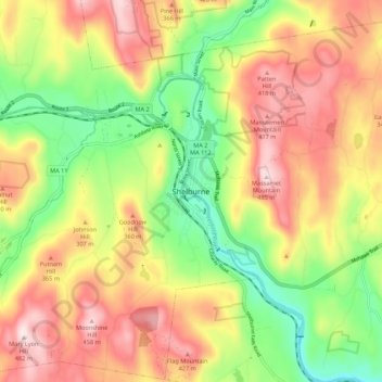
Nombre: Mapa topográfico Shelburne, altitud, relieve.
Altitud media: 266 m
Altitud mínima: 59 m
Altitud máxima: 480 m
Haz una donación
Otros mapas topográficos
Haga clic en un mapa para ver su topografía, su altitud y su relieve.
Haz una donación
Haz una donación
Erving
United States > Massachusetts > Franklin County
The town is home to a number of topographic features popular among outdoor recreation enthusiasts. Erving State Forest has recreation and seasonal camping facilities. The Millers River is used for fishing and whitewater kayaking. Northfield Mountain hosts cross country ski trails, hiking trails, and rock…
Altitud media: 255 m
Haz una donación
Haz una donación
Haz una donación
Haz una donación
Haz una donación
Haz una donación
Leverett
United States > Massachusetts > Franklin County
According to the United States Census Bureau, the town has a total area of 23.0 square miles (60 km2), of which 22.9 square miles (59 km2) are land and 0.1-square-mile (0.26 km2) (0.61%) is water. Leverett is located on the edge of the Pioneer Valley and the hills of northwestern Massachusetts, just east of…
Altitud media: 220 m
Haz una donación
Haz una donación