
Gracias por apoyar a este sitio ❤️
Haz una donación
Haz una donación
Mapa topográfico Gorges State Park
Haga clic en el mapa para ver la altitud.
Gracias por apoyar a este sitio ❤️
Haz una donación
Haz una donación
Gorges State Park
Following the flood, local citizens eventually sold large land tracts in the Gorges to Singer Sewing Machine Company, which logged most of the land. Then, in the 1940s and 1950s, Singer sold the land to Duke Energy Corporation. The corporation purchased the land for its steep topography and high rainfall, which offered opportunities for development of hydropower projects.
Gracias por apoyar a este sitio ❤️
Haz una donación
Haz una donación
Acerca de este mapa
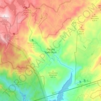
Nombre: Mapa topográfico Gorges State Park, altitud, relieve.
Altitud media: 682 m
Altitud mínima: 329 m
Altitud máxima: 1.081 m
Gracias por apoyar a este sitio ❤️
Haz una donación
Haz una donación
Otros mapas topográficos
Haga clic en un mapa para ver su topografía, su altitud y su relieve.
Gracias por apoyar a este sitio ❤️
Haz una donación
Haz una donación
Gracias por apoyar a este sitio ❤️
Haz una donación
Haz una donación
Gracias por apoyar a este sitio ❤️
Haz una donación
Haz una donación
Gracias por apoyar a este sitio ❤️
Haz una donación
Haz una donación
Gracias por apoyar a este sitio ❤️
Haz una donación
Haz una donación