
Haz una donación
Mapa topográfico Balsam Grove
Haga clic en el mapa para ver la altitud.
Haz una donación
Acerca de este mapa
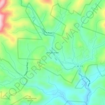
Nombre: Mapa topográfico Balsam Grove, altitud, relieve.
Altitud media: 914 m
Altitud mínima: 807 m
Altitud máxima: 1.154 m
Haz una donación
Otros mapas topográficos
Haga clic en un mapa para ver su topografía, su altitud y su relieve.
Dupont State Recreational Forest
United States > North Carolina > Transylvania County
Altitud media: 826 m
Haz una donación
Gorges State Park
United States > North Carolina > Transylvania County
Following the flood, local citizens eventually sold large land tracts in the Gorges to Singer Sewing Machine Company, which logged most of the land. Then, in the 1940s and 1950s, Singer sold the land to Duke Energy Corporation. The corporation purchased the land for its steep topography and high rainfall,…
Altitud media: 682 m
Dupont State Recreational Forest
United States > North Carolina > Transylvania County
Altitud media: 840 m
Haz una donación
Pisgah National Forest
United States > North Carolina > Transylvania County
The Pisgah National Forest covers 512,758 acres (801 sq mi; 2,075 km2) of mountainous terrain in the southern Appalachian Mountains, including parts of the Blue Ridge Mountains and Great Balsam Mountains. Elevations reach over 6,000 feet (1,800 m) and include some of the highest mountains in the eastern United…
Altitud media: 752 m