
Haz una donación
Mapa topográfico Ocean Shores
Haga clic en el mapa para ver la altitud.
Haz una donación
Ocean Shores
Ocean Shores is set on relatively flat coastal terrain. The city's elevation averages about 10 to 15 feet (3 to 5 meters) above sea level, typical for much of the Washington coast's beach communities. It sits on a spit of land between the Pacific Ocean to the west and Grays Harbor to the east. This unique location features extensive sandy beaches, dunes, and marshlands that support diverse ecosystems. The surrounding area includes low-lying tidal flats and coastal wetlands, contributing to the region's dynamic and frequently shifting landscape. Additionally, the terrain is marked by shallow bays and rivers that further shape the coastal environment, creating a scenic but vulnerable coastal zone.
Haz una donación
Acerca de este mapa
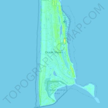
Nombre: Mapa topográfico Ocean Shores, altitud, relieve.
Altitud media: 1 m
Altitud mínima: -2 m
Altitud máxima: 19 m
Haz una donación
Otros mapas topográficos
Haga clic en un mapa para ver su topografía, su altitud y su relieve.
Haz una donación
Roosevelt Beach Conservation Area
United States > Washington > Grays Harbor County > Ocean Grove
Altitud media: 18 m
Haz una donación
Roosevelt Beach Conservation Area
United States > Washington > Grays Harbor County > Ocean Grove
Altitud media: 18 m
Haz una donación