
Haz una donación
Mapa topográfico Artic
Haga clic en el mapa para ver la altitud.
Haz una donación
Acerca de este mapa
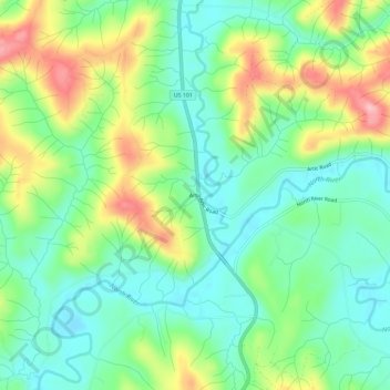
Nombre: Mapa topográfico Artic, altitud, relieve.
Lugar: Artic, Grays Harbor County, Washington, United States (46.87032 -123.73528 46.91032 -123.69528)
Altitud media: 75 m
Altitud mínima: 22 m
Altitud máxima: 175 m
Haz una donación
Otros mapas topográficos
Haga clic en un mapa para ver su topografía, su altitud y su relieve.
Ocean Shores
United States > Washington > Grays Harbor County
Ocean Shores is set on relatively flat coastal terrain. The city's elevation averages about 10 to 15 feet (3 to 5 meters) above sea level, typical for much of the Washington coast's beach communities. It sits on a spit of land between the Pacific Ocean to the west and Grays Harbor to the east. This unique…
Altitud media: 1 m
Aberdeen
United States > Washington > Grays Harbor County
Aberdeen is at the eastern end of Grays Harbor, near the mouth of the Chehalis River and southwest of the Olympic Mountains. Grays Harbor is notable as the northernmost ria on North America's Pacific Coast because it has remained free of glaciers throughout the Quaternary due to unfavorable topography and warm…
Altitud media: 48 m
Haz una donación
Haz una donación
Roosevelt Beach Conservation Area
United States > Washington > Grays Harbor County > Ocean Grove
Altitud media: 18 m
Haz una donación
Haz una donación
Aberdeen
United States > Washington > Grays Harbor County
Aberdeen is at the eastern end of Grays Harbor, near the mouth of the Chehalis River and southwest of the Olympic Mountains. Grays Harbor is notable as the northernmost ria on North America's Pacific Coast because it has remained free of glaciers throughout the Quaternary due to unfavorable topography and warm…
Altitud media: 48 m
Haz una donación
Roosevelt Beach Conservation Area
United States > Washington > Grays Harbor County > Ocean Grove
Altitud media: 18 m
Haz una donación