
Haz una donación
Mapa topográfico Emmaus
Haga clic en el mapa para ver la altitud.
Haz una donación
Emmaus
According to the U.S. Census Bureau, the borough has a total area of 2.9 square miles (7.5 km2), all land, though part of Little Lehigh Creek, a tributary of the Lehigh River, flows just outside the Emmaus border with Salisbury Township. Emmaus borders South Mountain, a large Appalachian mountain range. The town's elevation is 436 feet above sea level. Emmaus is located at approximately 40°32′13″N 75°29′45″W / 40.53694°N 75.49583°W / 40.53694; -75.49583. It has a hot-summer humid continental climate (Dfa) and is in hardiness zone 6b. Average monthly temperatures in the downtown vicinity range from 28.9 °F in January to 73.5 °F in July.
Haz una donación
Acerca de este mapa
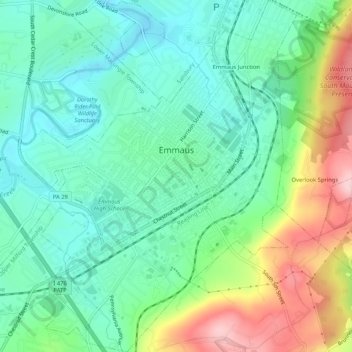
Nombre: Mapa topográfico Emmaus, altitud, relieve.
Lugar: Emmaus, Lehigh County, Pennsylvania, 18049, United States (40.51674 -75.52038 40.55645 -75.47900)
Altitud media: 154 m
Altitud mínima: 89 m
Altitud máxima: 296 m
Haz una donación
Otros mapas topográficos
Haga clic en un mapa para ver su topografía, su altitud y su relieve.
East Texas
United States > Pennsylvania > Lehigh County > Lower Macungie Township
Altitud media: 126 m
Centreville
United States > Pennsylvania > Lehigh County > Lower Macungie Township
Altitud media: 144 m
Haz una donación
Leather Corner Post
United States > Pennsylvania > Lehigh County > Lowhill Township
Altitud media: 178 m
South Mountain
United States > Pennsylvania > Lehigh County > Upper Saucon
Unlike Blue Mountain to its north, South Mountain does not follow a straight geographic line. The mountain ranges in elevation between 500 and 1,300 feet (150 and 400 m) above sea level. The ridge is made of metamorphic rocks and gneiss, which date to the Precambrian era and range from about 570 million to…
Altitud media: 153 m
Haz una donación
Vera Cruz Station
United States > Pennsylvania > Lehigh County > Upper Milford Township
Altitud media: 199 m
South Mountain
United States > Pennsylvania > Lehigh County > Upper Saucon
Unlike Blue Mountain to its north, South Mountain does not follow a straight geographic line. The mountain ranges in elevation between 500 and 1,300 feet (150 and 400 m) above sea level. The ridge is made of metamorphic rocks and gneiss, which date to the Precambrian era and range from about 570 million to…
Altitud media: 153 m
Haz una donación
Trexlertown
United States > Pennsylvania > Lehigh County > Upper Macungie Township
Trexlertown is located southwest of the center of Lehigh County along the southeastern edge of Upper Macungie Township at an altitude of 397 feet (121 m). It is bordered to the southwest by Breinigsville and to the southeast by Lower Macungie Township. U.S. Route 222 forms the northern edge of the community;…
Altitud media: 127 m
North Fogelsville
United States > Pennsylvania > Lehigh County > Upper Macungie Township > Fogelsville
Altitud media: 165 m
Kernsville
United States > Pennsylvania > Lehigh County > North Whitehall Township
Altitud media: 147 m
Haz una donación
Leather Corner Post
United States > Pennsylvania > Lehigh County > Lowhill Township
Altitud media: 178 m
Haz una donación
Weilersville
United States > Pennsylvania > Lehigh County > Lower Macungie Township
Altitud media: 126 m
Fogelsville
United States > Pennsylvania > Lehigh County > Upper Macungie Township
Altitud media: 155 m
Wescosville
United States > Pennsylvania > Lehigh County > Lower Macungie Township
Altitud media: 128 m
Haz una donación
Cherry Hill
United States > Pennsylvania > Lehigh County > Upper Macungie Township
Altitud media: 146 m
Weidasville
United States > Pennsylvania > Lehigh County > Lowhill Township > Weidasville
Altitud media: 170 m
Crackersport
United States > Pennsylvania > Lehigh County > South Whitehall Township
Altitud media: 138 m
Haz una donación