
Gracias por apoyar a este sitio ❤️
Haz una donación
Haz una donación
Mapa topográfico Ironton
Haga clic en el mapa para ver la altitud.
Gracias por apoyar a este sitio ❤️
Haz una donación
Haz una donación
Acerca de este mapa
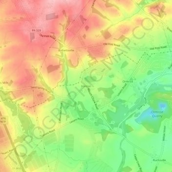
Nombre: Mapa topográfico Ironton, altitud, relieve.
Altitud media: 158 m
Altitud mínima: 82 m
Altitud máxima: 224 m
Gracias por apoyar a este sitio ❤️
Haz una donación
Haz una donación
Otros mapas topográficos
Haga clic en un mapa para ver su topografía, su altitud y su relieve.
Schnecksville
United States > Pennsylvania > Lehigh County > North Whitehall Township
According to the U.S. Census Bureau, Schnecksville has a total area of 2.7 square miles (7.0 km2), of which 0.01 square miles (0.02 km2), or 0.28%, are water. Schnecksville sits on a ridge at an elevation of about 660 feet (200 m) above sea level. To the west, water flows to Jordan Creek, while to the east…
Altitud media: 197 m